School House Steve wrote: For the vast majority of sailors a good commercial chartplotter and paying for charts is the way to go.[/
That's Me.
I have a Garmin GPSMap 3205 with depth finder and connected to a Raymarine auto helm. While I'm not intending to "knock" the idea of a lap top being used for a GPS, I'm only asking. Can it not only show you where you are but also show your boats compass heading, COG, Speed, position of Sun and Moon, sunrise, sunset, and tides? Can it show your battery voltage, depth, fish under the boat, VMG to next way point, ETA to destination? And can you pick a way point and have it steer the boat to it? My GPS can. On the other hand it can't text a message, surf the web, or play a DVD.

I have used my desk top computer to down load pictures from Goggle Earth for areas my GPS does not have chart information. Thanks to those of you who have posted addition places to down load maps I now have new resources of information.
Here is some copied info from the manual that might fill in a few blanks...
=========================================
Display Data Info....
Boat:
Update interval: Screen update interval for the boat
Shape: Type of boat marker.
Color: Color of boat and speed mark.
Size: Size of boat marker.
Radar Rings: Number of visible radar rings.
Ring Step: Step between rings, or select Auto for adaptive step. Adapts to fit screen.
Speed Marker: Number of seconds ahead for the speed mark. Set to 0 to turn off.
Language:
Language file: Select file containing language. See Language section.
Display:
Dashboard: Left or Right side.
Zoom with wheel: On/Off.
Look-ahead: On/Off to position most of the screen ahead of the ship. If set to off the chart
is positioned with the ship in the middle of the screen.
Update While Panning: (Disk mapped files) Update display while dragging with mouse.
Fat Cursors: Use bigger size more visible screen cursors.
HQ Zoom: Zoom out with more details. Slower on some systems.
Chart:
Chart Prefetch: Number of seconds to look ahead for best chart in Automatic mode.
Scroll Edge: Border of chart where mouse double-click will look for best chart.
New Chart Zoom: 100% or Last.
Route
Next Waypoint
Pre-Load. Time before arrival to waypoint when next waypoint is activated.
Wrong way max. If the ship is taking a different path then the route, the distance the current
waypoint may move in the wrong direction before the route is re-activated,
finding a new start of the route.
Acknowledge New WP: If checked, route panel will turn red until acknowledged. Acknowledge with
right-click menu on route panel or Ctrl + ‘N’ on keyboard.
Route Default
Default Speed: The default speed entered in a new waypoint.
Default XTE: The default XTE max error entered in a new waypoint.
Route Display
Normal Color: Color for normal display of waypoints.
Selected Color: Color for highlight display of waypoints.
Size: Marker size.
Line Width: Connecting line width.
Show Waypoint info. Show waypoint name on chart if available.
===========================================
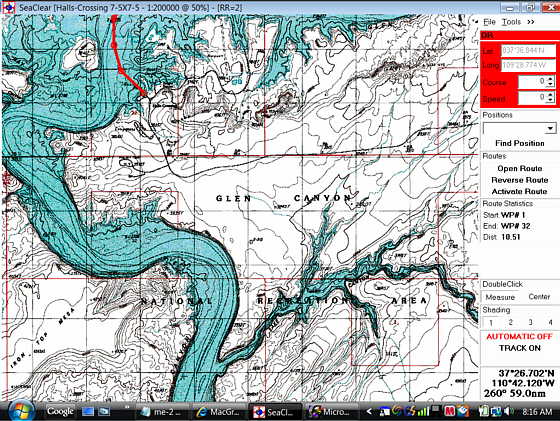
Display Menu Info:
Top Menu
GPS Status. Panel turns red if GPS data is lost.
Latitude
Longitude
True Course Over Ground
Speed Over Ground
Computed Magnetic Variation
UTC Time reported from GPS
GPS Based log
Trip (Right click to reset)
Running time hour counter (Right click to reset)
Position database access
Select position
Find it on the chart, load chart if necessary
Routes quick access
Loaded route statistics
Depth display. Only with NMEA depth transducer. Turns red to alarm.
Wind information. Only with NMEA wind transducer.
True direction and speed
Relative and Geographical direction
Velocity Parallel to Wind
Magnetic Compass. Only with NMEA compass transducer.
AIS Target info and locate with target-name dropdown list.
Not shown when in Automatic mode.
Select Measure or Center when double-clicking with mouse on chart.
Select shading level.
Click to toggle Automatic mode On/Off
Click to toggle Tracking On/Off.
With active route, click to toggle NMEA output On/Off
Cursor / Measure / Marker position, direction and distance.
When measuring, color is Lime.
When marker is set, color is Cyan.
Depending on connected NMEA devices, all panels may not show. Also, the size of screen may limit
available data. To display all panels a 1024 * 768 screen is needed. The panels will only display if
space is available,
===============================================
I can't see what it doesn't do that you would need for navigation, but wouldn't recommend it for the cockpit. Yet you can see a large area of the chart on a computer screen and plot a course in just a minute and download it into you handheld even quicker. So if you feel a handheld that will guide you from point to point and give you some of the other info you need like the sun/moon stuff then it can be a good alternative to a commercial chartplotter.
I've seen posts by commercial fishermen and other commercial boaters that use SeaClear as their primary navigation aid.
Still if you can afford a nice chartplotter like you have that might surely be the way to go for a lot of boaters,
Sum
Our Trips to...
Our Mac Pages
Mac Links