Page 1 of 3
FYI: Low cost GPS solution
Posted: Thu Aug 06, 2009 11:15 am
by red_sky_at_night
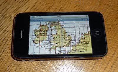
I'm not sure if this is the right forum to post this in, but I wanted to share an economical yet feature rich GPS solution with the community. Even if you already have an expensive chartplotter, this would be a great backup. It's an application for the iphone that uses the iphone's built in GPS receiver and is really a full featured navigation tool for only a few bucks. It may be reason enough to get yourself an iphone.
I was searching for marine applications on the iphone app store and came across this product from navionics:
http://www.youtube.com/watch?v=neN_6Tamcv8
http://www.navagear.com/2009/07/navioni ... ngbusters/
http://www.navionics.com/MobileMarineFeatures.asp
I also purchased a $3 wind reports application that shows current wind conditions from selected weather stations (but that's another post)
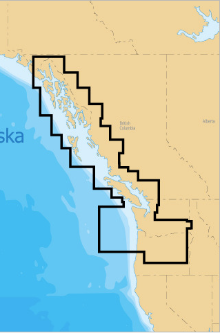
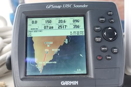
I tried Navionics out on a friend's boat and compared it to his $800 Garmin. I was impressed, to say the least. Best of all, it only costs $9.99. That's right, ten bucks for highly detailed charts for a large region (there are many regions available covering most of the globe), including POIs, tide information, currents, hazards, trip tracking, trip/waypoint planning, photo geo-tagging and many more features I haven't even tried yet. I chose the Marine: British Columbia region, which covers the waters from Oregon up to Alaska.
I just ordered a $10 flexible suction mount for my iphone from eBay and plan to mount it on the steering pedestal and provide power via a usb-12V adapter that I already use in my car for charging.

Re: FYI: Low cost GPS solution
Posted: Thu Aug 06, 2009 11:23 am
by red_sky_at_night
Tide information:
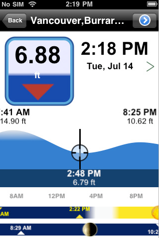
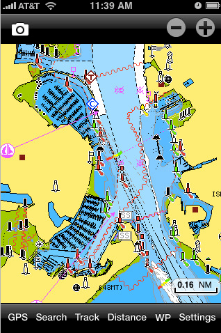
Chart detail showing buoys, hazards (app can be zoomed in much closer for detailed depth info):
Re: FYI: Low cost GPS solution
Posted: Thu Aug 06, 2009 12:08 pm
by parrothead
That looks like a very cool application

I love my iPhone, we use it on the boat for its live weather radar and ability to access local buoy sites for wind speed & direction. Just be sure to mount yours in a way that keeps it dry.... the iPhone does NOT LIKE to get wet

Re: FYI: Low cost GPS solution
Posted: Thu Aug 06, 2009 12:29 pm
by Divecoz
I guess its finally time to trade in my bag phone

Its getting heavy and I lost the strap......
Re: FYI: Low cost GPS solution
Posted: Thu Aug 06, 2009 12:55 pm
by red_sky_at_night
parrothead wrote:That looks like a very cool application
I love my iPhone, we use it on the boat for its live weather radar and ability to access local buoy sites for wind speed & direction. Just be sure to mount yours in a way that keeps it dry.... the iPhone does NOT LIKE to get wet
True, in big weather you might want to put it in a ziplock bag before putting it in the mount
Re: FYI: Low cost GPS solution
Posted: Thu Aug 06, 2009 2:14 pm
by blue angel
Do any of these units have preloaded maps for both frewhwater lakes/rivers
and
for marine/coastal?
As far as I know you have to cboose one of the other with garmen, and then add if you want both?
Do others have both?
Re: FYI: Low cost GPS solution
Posted: Thu Aug 06, 2009 2:58 pm
by richandlori
Imagine what would happen to this guy relying on too much on electronic Charts?
Just a little reminder.....
Rich
Re: FYI: Low cost GPS solution
Posted: Thu Aug 06, 2009 3:10 pm
by Rick Westlake
richandlori wrote:Imagine what would happen to this guy relying on too much on electronic Charts?
Just a little reminder.....
Rich
And
this looks like a good place to be reminded of something

I saw, years ago, in one of the nautical-chart offices in Defense Mapping Agency (as it was at the time) ...
Someone had doctored up one of our standard chart notations, blown it up on a Xerox machine, and put it up on the partition beside his big drafting table:
"WARNING - The prudent mariner will not rely on any single aid to navigation, especially DMA charts."


Re: FYI: Low cost GPS solution
Posted: Thu Aug 06, 2009 3:39 pm
by rfrye94760
I'm certainly no expert when it comes to navigation on the water but a lesson learned while taking flight instruction for new sailors like me.
Early in training my instructor had me using a moving map GPS. A couple lessons in he reached over and shut it off. As he expected within about 10 minutes I was completely lost even though I was only 20 minutes from my home field. He used this lesson as a tool for teaching the importance of learning how to navigate without electronic aids because they will fail at some point. After he was satisfied I could read a chart and a compass and compensate for wind drift while underway I was then allowed to use the GPS unit again. By then it was more fun to navigate the "old-fashioned" way.
Anyway, just a thought.
Re: FYI: Low cost GPS solution
Posted: Thu Aug 06, 2009 4:07 pm
by Duane Dunn, Allegro
I love the Navionics iPhone app. I run it on my iPod touch, so I don't have the live GPS at the moment, but I still find it very useful. The tide and current display is one of the most intuitive I have used and it is very useful for reference and planning. When some of the soon to be released GPS dongles come out for the iPod I'll pick one up for live moving maps. I also like that it is the exact same vector chart that I have in my Eagle GPS at the pedestal.
My only regret is that I was an early adopter and paid $49 for the app and charts. That was a good deal then to get all of Puget Sound, the Inside Passage, and Outside of Vancouver Island for $49 compared to the $199 the chip in my GPS cost. To get it all for $10 is now amazing.
Do beware that it is a very large iPhone/iPod app at 160+Mb. It takes a while to download on WiFi, loading it over the cell network would be very tedious. You are better off to download it with iTunes and then sync.
In addition to all the coastal area I believe the also have inland lakes charts available.
Re: FYI: Low cost GPS solution
Posted: Thu Aug 06, 2009 4:40 pm
by richandlori
We are overlooking the Big cost of the Iphone and the monthly service...but if you have that anyway...or as many do have it as a company expense...then it is a great way to get some charting!
Rich
Re: FYI: Low cost GPS solution
Posted: Thu Aug 06, 2009 6:39 pm
by Duane Dunn, Allegro
I'm actually very happy with the iPod Touch, everything the phone has except the phone. It's very fast on any available WiFi network. Cheaper, and no monthly service plan. Some day I'll switch my phone from the current business Blackberry 8900, but for now both work well together.
Re: FYI: Low cost GPS solution
Posted: Thu Aug 06, 2009 7:07 pm
by Divecoz
Rick Westlake wrote:richandlori wrote:Imagine what would happen to this guy relying on too much on electronic Charts?
Just a little reminder.....
Rich
And
this looks like a good place to be reminded of something
I saw, years ago, in one of the nautical-chart offices in Defense Mapping Agency (as it was at the time) ...
Someone had doctored up one of our standard chart notations, blown it up on a Xerox machine, and put it up on the partition beside his big drafting table:
"WARNING - The prudent mariner will not rely on any single aid to navigation, especially DMA charts."
Each has its place and on a bigger boat on bigger water you'd have two good size GPS and maybe what this new gadget as well. Charts ? Charts are salty but ... ...........btw its been a year time to venture beyond the s.o.c.

Re: FYI: Low cost GPS solution
Posted: Thu Aug 06, 2009 9:26 pm
by Bluecrab
What about service? We plan to get up to the Apostle Islands soon. I have been told some people rely on their cell phones rather that VHF, also that service gets poorer the further you are from Bayfield, which is the reason for having it in the first place.
One of my cube mates at work has one. We are about 20ft from the outside windows and he needs to have it in one exact spot to get service. Also there are the occasional dead spots in our area with just about any service provider.
One thing that phones with gps do now that I like is when you take a picture they geo tag the location.
They are also new, shiny and made by Apple
Thanks for sharing the info.
Wally
Re: FYI: Low cost GPS solution
Posted: Fri Aug 07, 2009 2:22 am
by jezbraker
also got the navionics app - very nice for the little £££ it cost! - not sure if the insurance covers my phone for lost at sea so i doubt ill use it in the cockpit to much though for the cost of the o2 insurance it bloody well should!. It'll be a nice backup of the backup once ive learnt how to read the backup (chart) and purchased a garmin or similar
