Chinook wrote:I recall reading in an Exuma cruising guide how to estimate tides based on the nearest tidal station, with appropriate time adjustments.
Yep it is in one of the books you suggested I get. I can't remember which and they are in Florida so I can't look . That is what I used. Really important info if you run a cut between the shallow water on the west side and deeper water on the east side of the Exumas to avoid a 'rage sea' at a cut. Also very important running a cut returning to Florida or going out. Also tide info is good to use if you take the Mac down one of the dinghy passages on the chart. I'll use tide info to move the Endeavour to some places I'd like to return to that are doubtful passages at low tide.
Is link to another cheap halfway decent sounding ais device that I also am going to play with in the keys to see if it is of any help at all....as far as antennas for vhf I made a blunder 2 years ago in buying stuff online and have 2 of them already lol
Most off all my well thought out purchases on eBay come late at night (sarcasm) and last night was no different I pulled the trigger on the garmin 545s and the gxm 31 ...only to wake up and realize they are not completely "plug n play" as the gxm31 has a micro usb out and no where on the garmin 545s is there a usb in.....scoured the net literally all day 3 calls to garmin the last guy i talked to took him 2 hours but he was willing to keep looking so I let him as he told me it was an old discontinued model and they didn't even have Info on it anymore but he said just like I had read the two somehow could be paired he just couldn't figure out how....2 hours later and after he found an old catalogue from 2007 he stumbled upon the 20 dollar part which ironically they still keep in stock .... part number 010-10919-00 which is the adapter and I'm told it should work perfectly..i posted the part number because of all the hundreds of threads I read on people pairing the two there was not one mention of this necessary adapter in hopes to save some future tightwad like myself googling gxm-31 adapter for gpsmap 545s for days on end lol....so i do believe I am going to give this trip to the exumas a shot..... I've now got ais and radar now figured out....even got approval from my boss today for 2 months of vacation next summer... not sure if the gas there is ethanol free but I have been practicing/ experimenting extracting ethanol from regular pump gas lately and to the best of my knowledge it's worked at removing ethanol pretty simple to do also
So now if I can just devise a way to capture rain water I may be in business .... granted this is next year's trip and I haven't even gone to the keys this summer but I wanted to use this year's trip as a testing ground for collecting rain / Does my $50 ais actually work and does my budget radar work etc etc
Thanks for the AIS link. Looks like lots of devices being developed. Are you going to be able to get the signal from the dAISy to your chartplotter? I had the radio talking to the computer running OpenCPN and the targets came up along with the ability to set up warnings in OpenCPN if it detected we were on a collision course (happened once) which is nice. I'll have the radio now connected to the computer with OpenCPN and to the Standard Horizon chartplotter for the same features. The dAISy connected to the Raspberry Pi will also work like that as it is sending the AIS info to OpenCPN....
whgoffrn wrote:.... not sure if the gas there is ethanol ...
The gas I got there was all ethanol free. Also I haven't found it hard to find it at marinas in Florida and the gas station just up the road from the boatyard where the Endeavour lives has it. Since we are a last stop on the way to Lake Powell one station here even carries it,
I have open cpn on our laptop and will prob put the other on the tablet....i bought both since they were so cheap but can't imagine the second one having very long reception with that little tiny antenna but I guess we will see. ....
I'm starting to see where this becomes addictive and never ending .... man/boat vs the sea ... i guess that's all part of the fun/ challenge trying to overcome the many obstacles you think you might encounter ....
The mental shopping list never ends lol
I haven't received either one in the mail yet but the last one (the link I posted) looks as if it has its own little antenna and doesn't plug into the vhf antenna and if that's true I can't imagine it having very long of a range with that little antenna that looks like it belongs on a remote control car
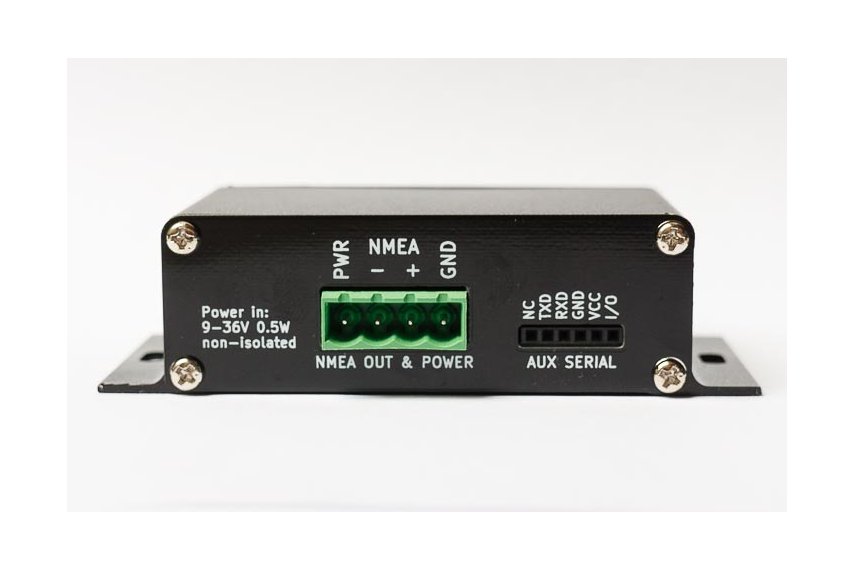
It is in an enclosure, you can power it from the boat's 12 volts and it would be easy to use the serial port on it to pass the info to the Garmin chartplotter. I'm assuming they provide a male plug for the green 12v/nmea connector on the side? They seem to get good reviews.
... if that is it, would be fine if you have a Raspberry Pi as it mounts right on it and sends the data to it and receives its power from it.
I might think about getting it myself as it would give me backup to the AIS data from the radio. I've been very happy with the Standard Horizon AIS radio as far as radio range and the AIS range is really good also. What radio do you have?
I have a standard horizon but it's just a cheapo radio....i was told the antenna is what gets you distance....i have 1 mast mounted antenna and another pretty good Shakespeare mounted on stern rail.
I think the daisy I'm gonna have go to the android tablet with mast mounted antenna and boat beacon app and the other one go to computer open cpn and see if that little cheap antenna it comes with gets decent distance
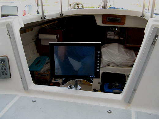
I have a Shakespeare at the top of the mast and got NOAA weather on the Standard Horizon 2100 over 100 miles off Florida. It would be really nice if you had the AIS targets visible at the helm.
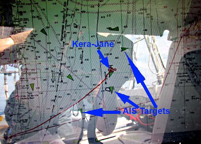
...where I can also see the AIS targets. Above you can see the Kera Jave very close to one. I called them and they asked if I could turn so that we would run past each other starboard to starboard and I did, which shows up on the track.
I ran the boat most of the time on the autopilot and sat mid-cockpit where I could still get on the tiller quickly and also see the monitor and any AIS targets. It is most important to see them between Florida and Nassau. Past there it is mostly private boats. Still the info is good if you want to talk to one of those boats, which I did a couple times.
Your are going to have the Garmin chartplotter so with some serial wires you could get the AIS to it easily with the one I posted and also you should be able to with the one you bought. Was it the one I linked to that fits on top of a Pi?
From what I can see it won't connect to the Garmin. At least not with a serial port.
My Standard Horizon CPN700i has WiFi built in but not sure it can receive AIS or any other nmea type data via the WiFi. Which Garmin model did you end up with? If it can receive nmea type data over WiFi that AIS might connect to it.
Also what was the first AIS device that you bought? Was it one of the dAISy models? They should work,
Yeah I bought the daisy first ...but I think the one you posted is a better version 2 channel maybe I should have opted for that but I wanted ais on my tablet on boat beacon
whgoffrn wrote:Yeah I bought the daisy first ...but I think the one you posted is a better version 2 channel maybe I should have opted for that but I wanted ais on my tablet on boat beacon
Sorry, I'm not meaning to run this into the ground as thousands of boats have gone to the Bahamas without AIS. I just feel that if you are getting the chartplotter and AIS, it sure would be nice to have the information of where your boat is and where any AIS targets are all on the same screen at the helm.
Boat Beacon looks like an interesting app but once you are a ways off shore and no longer have cell service it isn't going to do anything for you. Your chartplotter will be what you will be seeing and using.
Boat Beacon can let others know where you are at if the other boats are running it or a similar app. I doubt very much that the container ships, oil ships or cruise ships are running any of those apps. They hopefully are looking at their radar and their AIS targets near their ship. We don't show up well on their radar...
I used a radar reflector similar to the one above on the Mac on these crossing and twice came very close to large ships and neither saw me until I called them and told them where I was. Both times we were on collision courses, according to OpenCPN, or very near to being on one. I'm hoping they see the Endeavour better but I won't count on it.
Give me the link to the exact dAISy you bought. If it would be the one I'd like for my Raspberry Pi maybe I could possibly buy yours and you could get the one that would be easier to hook up,
Came home to find several packages on my door step..both ais devices and the garmin ...only waiting on xm antenna ..boat Christmas has came lol. The daisy I bought actually makes boat beacon work on the tablet when there is no cell service....so even when I'm out it will still receive ais but of course it won't transmit once im out of cell range.....the other I'll use on open cpn......ive got a long while to play around with which device works best or most practical....and that's why I'm gathering supplies now so I can use this upcoming trip to the keys as a testing ground .... none of this stuff is necessary in the keys but I'm gonna trial run it there ....the reason I chose that particular one is because I've been very impressed with navionics on our tablet thus far and how easy and simple it is to use and quickly scroll (plus being on a 10 inch screen) and slide ahead to check depths of where I intend to go and anchor.....using navionics on my tablet is so incredibly easy I'm not sure I will prefer the garmin over the tablet + navionics my garmin is an 8 year old 5 inch screen I assumed I probably would only use my garmin for weather only and not really use it quite as much for navigation....i guess it depends....it appears screen brightness will be brighter on a true GPS plotter but on such a small screen with old gps and the tablet being touch screen I've got some sea trials to figure out which I like better...tablet is useless in rain being a touch screen (even in a Ziploc bag it's not practical) but when the sun is really blaring down the brightness isn't the best but the 10" screen does help ......so each one is a trade off
One reason I'm also playing with ais is I don't own plb or an epirb....5-10 miles off coast in the keys I just never felt it was a necessity with 2 vhf 1 handheld.... now that I'm seeing more of a reason to look into them with semi younger kids who sometimes tend to not listen to what I tell them is a plb with the ais man over board....that way if in worse case scenario ....a mob would send signal not only to coast guard but also to my own boat so Id have my own gps of where they were at ....im gonna get some form of epirb or plbs if it's not too much more for one that will transmit an ais signal why not spring for that one......hopefully none of this stuff will need used its just for peace of mind
One or the other of the ais devices I have may actually work with the garmin if I find the graphics and useability of it isn't as bad as I thought..... I guess a few trials will tell but in all actuality I intend to use the tablet as my primary means of navigation unless I find despite a 5 inch screen the garmin 545s is a better choice